Blog Archive

Showing posts with label road. Show all posts

Tulip Refresher Course

I know that some of you guys/gals are more the follow the course tape type of people, so this "race" will be a change. The course will be given to you in two halves. You'll get tulip notes at raceday sign-in for the first half of the race. Once you get to the Zumbro Falls checkpoint you'll receive the instructions for the second half of the race. Approximate size of the notes will be 4.25" x 5.5" (maybe a bit smaller).

Each instruction will include an instruction number, an overall mileage, a tulip diagram and an information cell. The overall mileage will count up from the start or any place where you are instructed to reset your mileage, such as a checkpoint.

The tulip diagram is a graphical representation of the location for the instruction. Normally this is an intersection of two or more roads, or a feature of a road. The tulip always has two features, the dot and the arrow. No matter how the tulip is oriented, you always will travel from the dot to the arrow for that instruction. Normally the tulips are drawn so you are traveling from the bottom of the tulip, but this doesn't have to be the case.

Here is a sample note:
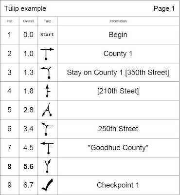


The first tulip of instruction 1 ("Begin") shows that the mileage is zero, so you would want to zero your odometer at that instruction.

The 2nd shows that you will approach a T intersection (in this case it's County road 1) and take a right. This intersection is aproximately 1.0 miles from the last zero.

The third instruction shows that the road turns left, with another road branching off on the right. When a road is in brackets, ex. [350th street], it is indicating the intersecting or connecting road, but NOT the road you take. So in our example above, we stay on County 1 which bends to the left and 350th street intersects from the right.

Instruction 4 is similar. Since 210th street is in brackets [], it indicates the intersecting road is 210th street, but the tulip shows we keep going straight.
!! When in doubt, always follow the tulip and ignore the street or road names provided.

Instruction 5 shows a more complex intersection that we approach from the bottom right and end up taking a hard left a the delta.

Instuction 6 shows that the road we are on bends right, but we take 250th Street that intersects from the left.

When information is in quotes and a small dash is shown on the tulip, as shown in instruction 7, it indicates the text that is on a sign. That sign will be where the dash is shown at the intersection.

Instruction 8 simply shows that we take a right at a Y intersection and that intersection is at approximately 5.6 miles from the last odometer zero.

Tulip 9 shows the location of a checkpoint.

In summary, the text is normally there to provide or clarify the instruction, but the primary thing you should focus on is the tulip. 
Always travel from dot to arrow, no matter how the tulip is oriented on the page.


Taken from http://ragnarok105.blogspot.com/

Some little nuggets about the probably 2011 course


1) The KOM lives. The first half of the race will be very similar to in years past (but not the same as previous editions).

2) We will still be going through Z-Falls. Hopefully the road out of town is able to be cleaned up a bit by the spring, but regardless the town was devastated by the fall rains. Driving through was a bit surreal, biking through could be the same.

3) There is no way for us to ever actually drive the whole course. Regardless of mode of transport (unless it is on two wheels).

4) I think that we have about the same amount of pavement as usual (not THAT much considering) with about twice or 3 times the minimum maintenance road mileage.


Taken from http://ragnarok105.blogspot.com/

Cue sheets 101


Our route instructions are listed in a 4 column format. Each instruction will include an instruction number, a mileage, a 'tulip' diagram and information. The mileage will count up from the start or any place where you are instructed to reset your mileage, such as a checkpoint.


The tulip diagram is a graphical representation of the feature for the instruction. Normally this is an intersection of two or more roads, or a feature of a road. The tulip has two features. The dot and the arrow. No matter how the tulip is shown, you will travel through the intersection from the dot to the arrow. Normally the tulips are drawn so you are traveling from the bottom of the tulip, but this doesn't have to be the case. Note: all mileages are rounded to the nearest tenth of a mile. Example:


Instruction 1 is at mile 27.2. The diagram indicates caution is required at that location and the info describes why.

Instruction 2 is at mile 27.3 and it indicates that you are to take a right at a 4 way intersection and end up on Water street.

Instruction 3 shows a more complicated intersection where 3 roads meet. Here you would take the 90 degree right onto 355th street.

Instruction 4 indicates you should continue straight past an intersection with 200th street. When a name is in square brackets, it indicates the crossing street or road.

Instruction 5 shows one of the "King of the Mountain" locations. We will score the first several riders to this location for that competition. For the following riders, this location doesn't mean much, other than the top of a hill.

Instruction 6 shows that the primary road curves left, but you will take the secondary road to the right. In this case, the secondary road is 380th street.

Instruction 7 shows a turn onto a Minimum Maintenance road. The dashed line indicates the road is a less prominent road than a regular road.

Instruction 8 shows a checkpoint. At each checkpoint, make sure the person working that location has your number before you leave. You may also need to get a new set of cue notes at that location.

In summary, the text is normally there to provide or clarify the instruction, but the primary thing you should focus on is the tulip. Always travel from dot to arrow, no matter how the tulip is oriented on the page.


Taken from http://ragnarok105.blogspot.com/

2 Months, 18 days!!! hope your riding!


With the beautiful weather we were treated with yesterday I managed to hop on the steed and get a ride in. The roads we mostly frozen, the tops of the hills were PB. Min maintenance road still have snowmobile traffic on them (that was scary). I did manage to snap some pics I'll get them posted up soon.

Safe riding!


Taken from http://ragnarok105.blogspot.com/

Tulip note reading 101


The dot on the tulip note is you, moving forward...

The arrow is the direction you go. If it's a left turn, the arrow points to the left. Etc.

Each tulip is drawn to replicate (or at least generally replicate) the intersection that you are going through. Follow the arrow!

When there is a note in [brackets] that is the road that you are crossing/passing/NOT going on. So for example this year at mile 11.7 you will take a right. The information/note says "stay on old Church road [Hill Valley road]". That means that you take a right while staying on Old Church road and the intersecting road, that you don't ride onto at this point, is Hill Valley.

We have noted the KOM locations in the first half of the race. These distances are approximate. We will try to match up where we are parked as close as possible, but it won't be perfect. We will make all attempts reasonable to make the KOM point clear. Most likely unless otherwise noted assume it's the back of the vehicle.

Thanks for reading... only a few more days!!!!


Taken from http://ragnarok105.blogspot.com/

Some final notes


  • A front and a rear light is required to be on at all times on the course.
  • A Helmet must be worn at all times progressing down the course.
  • You really should have a computer to help with navigation.
  • A fully charged cell phone is also a very good idea. You will need some way of contacting the outside world. We will not look for you if you don't make it to checkpoints.
  • Rain jackets/pants/whatever you need to traverse 100+ miles while in possibly drizzly, possibly windy, probably cold (think 35-40 degrees) weather.
PLEASE note that Colvill Park currently does not have any open bathrooms. As you head into town please take advantage of the many convenience stores or fast food joints to make that pit stop.

Here is a google link of key points - start and checkpoints

Some directions to Colville park (note that you'll want to go through town if you want to go to the bathroom):


Coming into Red Wing from the north on

US Hwy
61

Once in or near Red Wing take Highway 61 through town towards the south.
Outside of town about 1.5 miles, you will want to exit the highway to the right (there is a sign for a city park).

(This is the first and only exit south of town on the 4 lane stretch. If you get to where the road goes back to 2 lanes, you just missed your turn. If you miss it, take the very next right hand turn into the correctional facility [MN 252], drive through the lot and keep going on that street. This will bring you back to the missed exit)

Take a right on the frontage road and another immediate right onto Nyphara lane.
At the bottom of the hill, take another right under the bridges.
Once in the park, keep to the right and look for the group of cyclists.

Coming into Red wing from the west or south on
State Hwy
58

As you come into Red Wing, after the first stop light, the road will become two lanes at the bottom of a big hill.
Continue on this road as it heads towards downtown on Hwy 58/Bush street. Then you get to

7th Street
, you will take a right onto
7th street

(There is a liquor store on the right and a Kwik Trip on your left.)

Take

7th street
for about 1.5 miles.
When you can see Hwy 61 on your left, take a left onto Nymphara lane.
Take another left at the bottom of the hill under the bridges
Once in the park, keep to the right and look for the group of cyclists. Coming into Red Wing from the south on
US Hwy
61

As you approach Red Wing, Highway 61 will turn into 4 lanes.
Immediately after it becomes 4 lanes, take the exit on the left.
Take a right on the frontage road and another immediate right onto Nyphara lane.
At the bottom of the hill, take another right under the bridges.
Once in the park, keep to the right and look for the group of cyclists.


Taken from http://ragnarok105.blogspot.com/

CREEPING CLOSER!!!


Conditions on course last Saturday:

Yes, that is a minimum maintenance road, and yes that is 3-4 inches of snow on it. At least two sections of min. maintenance road that you will have to contend with. I would guess by the middle of April the snow will be gone (but what will be in it's place???? those who finished last year remember what can happen.... mwah ha ha haaaa).

Final, Final, Updated, Final, Official Roster will be posted later this week. If you haven't heard from me in one way shape or form via email consider yourself unlucky and not in. Sorry!


Taken from http://ragnarok105.blogspot.com/

Tulip Notes 101


Each instruction will include an instruction number, an overall mileage, a tulip diagram and an information cell. The overall mileage will count up from the start or any place where you are instructed to reset your mileage, such as a checkpoint.

The tulip diagram is a graphical representation of the location for the instruction. Normally this is an intersection of two or more roads, or a feature of a road. The tulip always has two features, the dot and the arrow. No matter how the tulip is oriented, you always will travel from the dot to the arrow for that instruction. Normally the tulips are drawn so you are traveling from the bottom of the tulip, but this doesn't have to be the case.

Here is a sample note:


The first tulip of instruction 1 ("Begin") shows that the mileage is zero, so you would want to zero your odometer at that instruction.

The 2nd shows that you will approach a T intersection (in this case it's County road 1) and take a right. This intersection is aproximately 1.0 miles from the last zero.

The third instruction shows that the road turns left, with another road branching off on the right. When a road is in brackets, ex. [350th street], it is indicating the intersecting or connecting road, but NOT the road you take. So in our example above, we stay on County 1 which bends to the left and 350th street intersects from the right.

Instruction 4 is similar. Since 210th street is in brackets [], it indicates the intersecting road is 210th street, but the tulip shows we keep going straight.
!! When in doubt, always follow the tulip and ignore the street or road names provided.

Instruction 5 shows a more complex intersection that we approach from the bottom right and end up taking a hard left a the delta.

Instuction 6 shows that the road we are on bends right, but we take 250th Street that intersects from the left.

When information is in quotes and a small dash is shown on the tulip, as shown in instruction 7, it indicates the text that is on a sign. That sign will be where the dash is shown at the intersection.

Instruction 8 simply shows that we take a right at a Y intersection and that intersection is at approximately 5.6 miles from the last odometer zero.

Tulip 9 shows the location of a checkpoint.

In summary, the text is normally there to provide or clarify the instruction, but the primary thing you should focus on is the tulip.
Always travel from dot to arrow, no matter how the tulip is oriented on the page.


Taken from http://ragnarok105.blogspot.com/